EUROPEAN CETACEAN BYCATCH CAMPAIGN
"Man is but a strand in the complex web of life"
"Man is but a strand in the complex web of life"
Seabed environmental damage caused by trawling operations
Trawling Impact Studies
AMASON - Trawling Impacts
(Hellenic Centre for Marine Research)
Trawl Mark Definition
Trawl marks are produced by contact of the trawl with the seabed in the direction of tow. This causes a number of distinct features from different parts of the trawl.
Door marks: the most distinctive feature, caused by the trawl doors, wooden or metal doors acting like wings, spreading the tow warps and keeping the mouth of the trawl open. The doors make parallel mirrored plough-like marks, that in soft sediments may penetrate up to 40 cm.
Wire scrape marks: single or multiple parallel, non-continuous marks caused by the towing warps contacting the seabed. These may not be apparent in hard sediments
Flattened areas: Caused by the ground rope and belly of the trawl scraping over the sediment surface and flattening local microtopography
Trawl marks may not always be exactly parallel or symmetrical and there are marked differences in different types of sediment. Most marks may be in the same general direction along fishing lanes, but in other more open areas they may criss-cross without any prevailing direction. Left over time marks will ‘age’ due to hydrodynamic and/or biological activity, where hard edges will soften and the plough marks will gradually fill-in. Continuous trawling in the same area will lead to fill-in and smoothing of older traces.
Video Imaging of Trawl Marks
With video, images may cover several metres with a resolution of at least 2 cm. All the features mentioned above may be obvious. However, the area that can be covered by video is generally small as deployment speed of video is normally less than 1 knot.
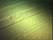
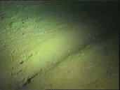
Grabbed video images are shown below demonstrating some of the different sedimentary impacts of trawling and untrawled areas. The images are from a trawl ground in Crete with a soft silty sediment at approximately 200 m depth.
Untrawled areas:
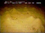
Bioturbation mounds in an untrawled area.
Fig 1
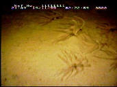
Surface epifauna – the crinoid Leptometra phalangium on the sediment surface.
Fig 2
Trawled areas:
Trawl door mark with bioturbation mounds in the background.
Fig 3
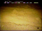
Fresh spoil heap from trawl door mark with scrape marks in the background.
Fig 4
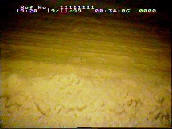
Wire scrape marks on flattened ‘soft’ sediment with feeding trail mark evident.
Fig 5
Old trawl door marks with rounded edges.
Fig 6
Side Scan Sonar Imaging of Trawl Marks
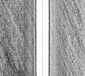
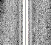
Side scan sonar may cover areas of 100+ metres with a resolution of 15-20 cm (depending on frequency). Trawl door marks can be individually imaged and followed over several hundred metres, but their dimensions are less easy to calculate and they may not be seen in very coarse sediments, smaller marks (wire scrapes and flattening) may not be distinguishable. Trawl marks may not be seen at all in sonar images if imaged at high angle of incidence or if the tow direction is perpendicular to the direction of towing.
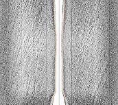
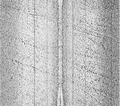
The following examples are from a Geoacoustics side-scan system, 410 kHz, vertical parallel scale bars at 20 m separation.
Along track side scan sonar image at a minimum 4 m above soft sea bed.
Fig 7
Cross track side scan image approximately 5 m above soft sea bed (corrected image).
Fig 8
Diagonal track side scan image approximately 18 m above coarse sea bed.
Fig 9
Trawl and Agassiz trawl marks on coarse sea bed. Maerly sand in top left.
Fig 10
Additional information regarding trawl impact damage
Environmental impact of trawling on the seabed: a review
Jones 1992 - pdf 845KB
Comparison of rapid methodologies for quantifying environmental impacts of otter trawls - Coggan, et al June 2001
pdf 3.8MB
Analysing the impact of bottom trawls on sedimentary seabeds with sediment profile imagery - Smith, et al September 2000 pdf 619 KB
Top
Trawling Impact Studies
AMASON -
(Hellenic Centre for Marine Research)
Trawl Mark Definition
Trawl marks are produced by contact of the trawl with the seabed in the direction of tow. This causes a number of distinct features from different parts of the trawl.
Door marks: the most distinctive feature, caused by the trawl doors, wooden or metal doors acting like wings, spreading the tow warps and keeping the mouth of the trawl open. The doors make parallel mirrored plough-
Wire scrape marks: single or multiple parallel, non-
Flattened areas: Caused by the ground rope and belly of the trawl scraping over the sediment surface and flattening local microtopography
Trawl marks may not always be exactly parallel or symmetrical and there are marked differences in different types of sediment. Most marks may be in the same general direction along fishing lanes, but in other more open areas they may criss-
Video Imaging of Trawl Marks
With video, images may cover several metres with a resolution of at least 2 cm. All the features mentioned above may be obvious. However, the area that can be covered by video is generally small as deployment speed of video is normally less than 1 knot.
Grabbed video images are shown below demonstrating some of the different sedimentary impacts of trawling and untrawled areas. The images are from a trawl ground in Crete with a soft silty sediment at approximately 200 m depth.
Untrawled areas:
Bioturbation mounds in an untrawled area.
Fig 1
Surface epifauna – the crinoid Leptometra phalangium on the sediment surface.
Fig 2
Trawled areas:
Trawl door mark with bioturbation mounds in the background.
Fig 3
Fresh spoil heap from trawl door mark with scrape marks in the background.
Fig 4
Wire scrape marks on flattened ‘soft’ sediment with feeding trail mark evident.
Fig 5
Old trawl door marks with rounded edges.
Fig 6
Side Scan Sonar Imaging of Trawl Marks
Side scan sonar may cover areas of 100+ metres with a resolution of 15-
The following examples are from a Geoacoustics side-
Along track side scan sonar image at a minimum 4 m above soft sea bed.
Fig 7
Cross track side scan image approximately 5 m above soft sea bed (corrected image).
Fig 8
Diagonal track side scan image approximately 18 m above coarse sea bed.
Fig 9
Trawl and Agassiz trawl marks on coarse sea bed. Maerly sand in top left.
Fig 10
Additional information regarding trawl impact damage
Environmental impact of trawling on the seabed: a review
Jones 1992 -
Comparison of rapid methodologies for quantifying environmental impacts of otter trawls -
pdf 3.8MB
Analysing the impact of bottom trawls on sedimentary seabeds with sediment profile imagery -
Top
Additional information regarding trawl impact damage
Environmental impact of trawling on the seabed: a review
Jones 1992 - pdf 845KB
Comparison of rapid methodologies for quantifying environmental impacts of otter trawls - Coggan, et al June 2001
pdf 3.8MB
Analysing the impact of bottom trawls on sedimentary seabeds with sediment profile imagery - Smith, et al September 2000 pdf 619 KB
Environmental impact of trawling on the seabed: a review
Jones 1992 -
Comparison of rapid methodologies for quantifying environmental impacts of otter trawls -
pdf 3.8MB
Analysing the impact of bottom trawls on sedimentary seabeds with sediment profile imagery -